Remove Disaster Remove Local Remove Map Remove Nonprofit
article thumbnail

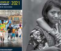
Lessons from 2019 to maximize future disaster giving decisions

Candid

Earlier this month, Candid and the Center for Disaster Philanthropy (CDP) released the eighth edition of our annual Measuring the State of Disaster Philanthropy report. global disaster-related?philanthropy,?analyzing?funding Support underfunded areas of the disaster lifecycle. In it, we examined?available?2019?data

article thumbnail

Apps for Disaster Planning

Tech Soup

TechSoup recently updated its disaster planning and recovery guide, The Resilient Organization , to include the new ways nonprofits, charities, and public libraries are using technology. Android, iOS, Windows Phone) connects you with friends and family during a large-scale disaster such as an earthquake or a hurricane.

professionals

Sign Up for our Newsletter

This site is protected by reCAPTCHA and the Google Privacy Policy and Terms of Service apply.

article thumbnail

Technology's Impact on Disaster Relief

Tech Soup

Mobile technology, web apps, and mapping software have become enormously helpful in sharing news and spreading information about relief efforts after Hurricane Sandy. has an interactive map that shows the flooding and weather information post-Sandy. project has a slew of resources for both responders and those affected by disasters.

article thumbnail

Giving Trends in Kenya: How the Growth of Mobile Payments Are Transforming Community Giving

Nonprofit Tech for Good

In the local context, Kenyan’s give an extremely high proportion of their earnings as donations (cc. The lack of trust between NGOs and local Kenyans and the expectancy that NGOs are funded from outside Kenya are the key reasons for limited local fundraising towards NGO in Kenya.

Kenya 196
article thumbnail

Webinar Recap: The Future of the Map

NTEN

Geographic Information Systems are powerful tools nonprofits can use to achieve their missions. Beyond just mapping existing data, some GIS systems are working to incorporate ways for mobile smart phone and cell phone users to collect data and update maps. Do you use GIS systems in your work?

Map 56
article thumbnail

Preparing for the Next Disaster: The Future of #crisisdata

NTEN

Unfortunately, this isn't Domino's Pizza and disaster response can't work as if it is. The American Red Cross is now looking into how best to give the public an increased role in disaster response. It was used after the earthquake to map actionable information, using the volunteer efforts of thousands of people around the world.

article thumbnail

Cool App Roundup: Disaster and Emergency Edition

Tech Soup

This edition of the App It Up project "Cool App Roundup" highlights different ways apps can be used in disaster, crisis, and emergency situations. Preparing for Disaster. The FEMA app includes preparation guidelines for a variety of disasters, including checklists, safety tips, and local shelter maps.