article thumbnail

Activating Damage Assessment System for Hurricane Ian

VisionLink

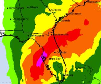
Currently focused on Flo rida’s Gulf Coast, Hurricane Ian’s particular track, combined with the shape of the bay, means that significant storm surges may inundate the Tampa Bay region. Because of the slow-moving storm, other more distant areas may also receive large amounts of rain or coastal surge.

Hurricane 246
article thumbnail

Hurricane Sandy Situational Map

VisionLink

Our thoughts and prayers go out to the dozens who lost their lives, their families, and to the many more recovering from what appears to be the 5th most serious hurricane on record. It is creat ed using a simple mapping tool in CommunityOS, thus there is no data to transfer or convert and at no extra cost.

Hurricane 187
professionals

Sign Up for our Newsletter

This site is protected by reCAPTCHA and the Google Privacy Policy and Terms of Service apply.

article thumbnail

Geo-Tagged Map Shows Impact of Hurricane Joaquin in Real Time

VisionLink

Map illustrates damage reports as hurricane hits North Carolina. 5, 2015— VisionLink , a community inspired software and consulting company, has developed a free, shareable, real-time, geo-tagged map depicting actual damage reports produced by Hurricane Joaquin. BOULDER, Colo. —

Hurricane 100
article thumbnail

Using Geospatial Maps in Time of Disaster

VisionLink

Geospatial mapping is an increasingly hot topic in large-scale natural disasters, including Hurricane Sandy and the Oklahoma Tornadoes. As technology continues to advance, data mapping is moving from being a powerful tool for specific cases to being a new norm in all disaster relief. Sincerely, VisionLink'

Disaster 149
article thumbnail

Philgorithms: Two Examples of Data Mapping to Guide Donor Decisions

Beth's Blog: How Nonprofits Can Use Social Media

As COVID accelerates innovative uses of AI in many areas, we are also seeing more development of AI-powered data mapping tools for philanthropic advising and to support donor investment decisions. The post Philgorithms: Two Examples of Data Mapping to Guide Donor Decisions first appeared on Beth’s Blog. NAVi seeks to fill these gaps.

Map 61
article thumbnail

NNTSP Applies Relief Work for Hurricane Sandy

Tech Soup

Several of the NNTSP partners are combining efforts for a response to Hurricane Sandy. You can help by making offers of technology devices and other support via Microsoft's ReadyReach Hurricane Sandy Portal , or at: National Donations Management Network Pennsylvania. What Can You Do to Help? Aidmatrix New York City.

article thumbnail

Visionlink Supports Dorian Response

VisionLink

Visionlink systems are fully engaged with Hurricane Dorian response. If you would like to check on currently open shelters you can visit the public view of the Shelter System at the Red Cross: Map of Open Shelters.

Support 100